When it comes to radar coverage studies, two popular methods often come into play: using ATDI software and the ray tracing method. Both approaches are valuable for different reasons, offering unique strengths depending on the complexity and specific requirements of the project.
Here’s a comparison of these two methods in the context of radar studies:
ATDI Software for Radar Studies
Integrated Geographic Information System (GIS):
ATDI uses GIS-based terrain models to calculate radar coverage over complex landscapes. The software integrates geographic data with simulation models, making it especially useful for real-world environments like urban areas, mountainous terrain, or offshore platforms.
Frequency and Propagation Models:
ATDI software allows for the simulation of different radar frequency bands, taking into account terrain, atmospheric conditions, and propagation losses. It provides highly accurate predictions of radar signal behavior.
Simulation of Complex Scenarios:
The software can simulate complex real-world scenarios such as interference between radars, effects of weather, and interactions between various radar and communication systems. This is crucial in maritime, military, or large-scale industrial applications.
Interference and Jamming Analysis:
ATDI can also model and simulate the effect of interference and radar jamming in a complex environment, offering insight into how resilient a radar system is under adverse conditions.
User-Friendly Interface:
Despite its complexity, ATDI is designed for ease of use, allowing engineers and system planners to perform sophisticated analyses without needing in-depth programming or modeling expertise.
Ray Tracing Method for Radar Studies
The ray tracing method is another common technique used for radar coverage studies, especially in areas with complex environments where multiple reflections, diffractions, and obstacles need to be considered.
Line-of-Sight and Reflection Calculations:
Ray tracing models how radar waves propagate through an environment by calculating how waves bounce off surfaces and pass through different materials. This is crucial in scenarios where buildings, terrain features, or other structures cause significant reflections or blockages.
Multiple Reflections and Diffractions:
Ray tracing is highly effective for understanding how waves interact with multiple surfaces. It can trace how waves reflect, diffract, or scatter after hitting objects, providing detailed insight into signal behavior in complex environments.
Highly Accurate for Complex Environments:
Ray tracing excels in highly reflective environments like urban areas or industrial complexes where radar signals may bounce between buildings or structures. It provides detailed results where signal behavior is too complex for simple models.
Frequency-Dependent Behavior:
Radar behavior varies depending on the frequency used. Ray tracing takes into account how different frequencies interact with objects, providing a detailed model of how radar systems perform across different bands.
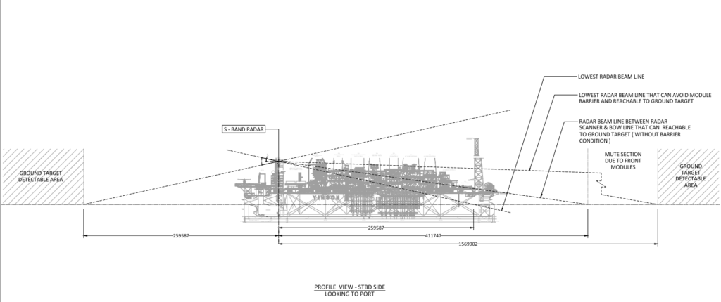
ATDI Software vs. Ray Tracing Method: A Comparative Overview
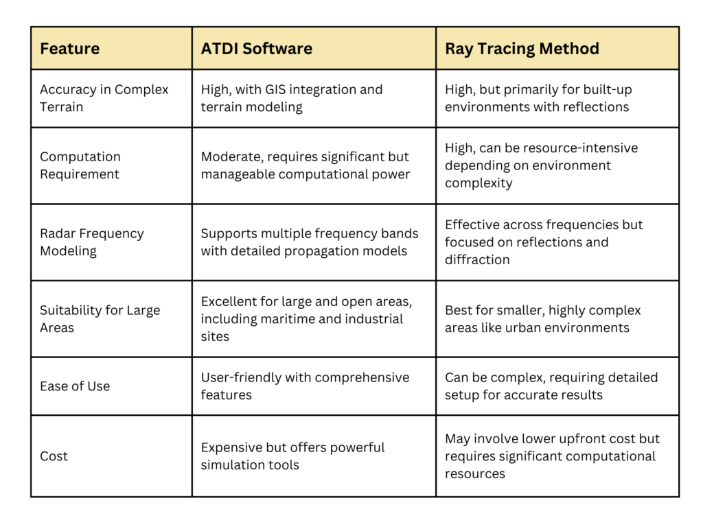
Use ATDI Software if:
- You need detailed GIS-based modeling for large areas such as maritime environments or industrial sites.
- Your project requires comprehensive radar coverage and interference analysis across varied terrains.
- You need to simulate complex, multi-radar or multi-frequency systems, with high attention to propagation and environmental effects.
Use Ray Tracing if:
- The radar study focuses on environments with many reflective surfaces (e.g., urban or industrial settings) where signal reflections and diffractions are key to coverage.
- You are analyzing smaller areas where high computational detail is necessary to model complex interactions of radar waves with objects.
- The project is constrained by time or cost, and simpler environmental factors can be assumed without significant loss of detail.
Get the Right Team
Team Vivo is experienced in conducting radar coverage studies for a variety of industries such as offshore platforms, FPSO vessels, oilfields and more.
By understanding the strengths and limitations of ATDI software and the ray tracing method, we choose the right tool for your radar study depending on the scale, complexity, and environment.

